
Context
Geo212 and Pixstart winned the “Challenge Collectivité” contest (as part of the Innovation Copernicus challenges). We created a POC (Proof of Concept) about deforestation and artisanal gold mining in Ivory Coast for the CURAT (Centre Universitaire de Recherche Appliquée en Télédétection, Côte d’Ivoire). Webinaire
Project description
Pixstart implemented an algorithm to “detect losses in vegetation cover” in Yamoussoukro region. Geo212 prepared samples of geospatial data to supply the machine learning, which helped Pixstart to calibrate their algorithm. Then, Geo212 validated the automatically extracted areas by photointerpretation.
Alongside, Geo212, who has geographic knowledge and expertise of the area of interest, proposed an expert system: modelisation of gold mining development conditions in this part of Ivory Coast. This allowed to automatically qualify the areas extracted from AI.

Evolution of an artisanal gold mining site
Photointerpretation data and various open-sources data were gathered in order to create a relevant data stack for the project:
For the machine learning:
- Sentinel 1 (radar) and Sentinel 2 (optical) satellite imagery, and VHR imagery (from open sources and Maxar)
- Small areas were established by photointerpretation on control sample areas to identify gold mining areas and deforested areas. This analysis allowed to improve training zones for machine learning by distinguishing seasonal vegetation changes from burned areas (for crops), from inundated crop areas (rice fields), from human constructions (roads, buildings…)
For the expert system:
- Hydrographic data (ranked rivers network, water areas, wetlands)
- Slope modelisation (from ALOS elevation model)
- Maps of active mines and mining
- Road network from OpenStreetMap, ranked and processed by Geo212 tools.
These data are implemented in an algorithm, adding a confidence level about the probability that the deforested areas are caused by gold mining.
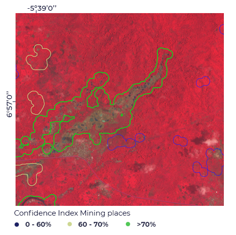
This leaded to an effective detection: 89% of automatically extracted areas by the algorithm are actual gold mining sites, answering the initial POC (Proof of Concept) needs.