FR
Services
Expertise
Projects
About
News
Geographic studies Data production and analysis Decision support Monitoring Consulting services ©OpenStreetMap services
Expertise Projects
About Values Key numbers Team
News
FR

Projects

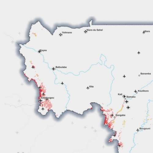
  • Inventory of gold mining in Mali

    Carrying out a geospatial inventory of gold mining sites in Mali in 2016, 2019 and 2022 and analysing their dynamics. Analyse the location of gold mines in regards to trade/smuggling routes, airstrips, nearest borders and customs checkpoints. Demonstrate how geospatial data and spatial analysis can be used to compare the dynamics of industrial mines with revenue evolution in 2016 and 2022, and detect anomalies.

    Open
  • IPHG 2022 - SOPSEA Which human geographical characteristics contribute to the instability in the Horn of Africa?

    To collect information to feed a standardized geographic database compliant to the international standards (IPHG) with human geography information to support a global multiscale understanding of a region of the world.

    Open
  • Prototype of an Observatory to manage Gold mining and Security in the Liptako Gourma area

    Develop a prototype GIS observatory for monitoring gold mining and its impacts on Security in Liptako-Gourma using Earth Observation data and geolocated data. Validate with the ALG the geospatial data layers and geospatial analyses relevant for decision-making. Define the roles and relations between the LGA and its member states (Mali, Burkina Faso and Niger).

    Open
  • 2000 cities / OneAtlas

    Within the scope of the OneAtlas project, Airbus needed the location and areas of the main 2000 urban areas of the world, in order to optimise satellite acquisitions.

    Open
  • Illegal artisanal gold mining areas mapping in Ivory Coast

    Bringing operational expertise to develop a monitoring service of artisanal gold mining in Ivory Coast, using Sentinel 1 & 2 imagery AI analysis (Pixstart) and cartographic data from an expert service of qualification.

    Open
  • Geospatial study for customs units redeployment in Niger

    Mapping Niger cross-border flows and analysing their activity from multi sources data and satellite imagery.

    Open
  • GeoMaps

    Producing geographic studies to estimate production effort and to de-risk cartographic production (scales 1/5 000 and 1/50 000) for French MoD. News watch and technologic watch surveys for geospatial new products which could impact the project. Reference and high value data production to supply cartographic production.

    Open
  • GEOSOCLE

    Providing geographic studies to assist the production of a satellite imagery basemap for French MoD. Creating zoning maps to prioritise and guide Pléiades and SPOT 6/7 imagery acquisitions. Conducting technologic watch surveys for geospatial new products which could impact the project.

    Open
  • Anthropization indicator for updating geospatial databases

    To develop a semi-automatic tool to detect anthropized areas, to master and optimize the update of a geospatial database.

    Open
  • Change detection on Sentinel-1 radar images

    To design and implement an "as automatic as possible" change detection process with S1 radar imagery over large areas.

    Open
  • Monitoring study on future satellite constellations

    To have an up-to-date knowledge of the development of future earth observation satellite constellations.

    Open
  • OSM Evolution

    To offer a cartographic view of the richness of the OSM database and its evolution.This service is intended for anyone who wishes to improve their knowledge of OSM data, its life cycle and optimize its use.

    Open
  • Hovering Horizon Newsletter

    Writing of a bimonthly newsletter on topics with strategic interest in the field of space and earth Observation for the European Union.

    Open

Contact

25 Bis rue Jean Dolent
75014 Paris
France
+33 1 45 45 46 61
contact@geo212.fr

GEO212

Services & Products Expertise Projects About News
Terms of use / Credits © Geo212 - 2021